Welcome to the official website of the Michigan Geological Survey (MGS). Our team of scientists works to better understand, preserve, and share Michigan geology. Using best available scientific methods, the survey conducts and facilitates geological investigations of Michigan’s natural resources and provides the public access to the state geological data repository.
- Use the Programs and Resources menu to browse all MGS content or use the Popular Topics menu to find information more quickly.
- To learn more about the importance of geologic mapping in Michigan, download our Geologic Map Flyer or visit our About page for additional details.
- To catch up on what’s happening at MGS, check out our Core Quarterly Newsletter.
MGRRE Building Updates
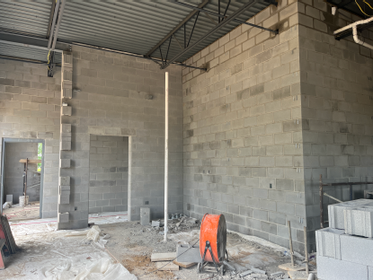
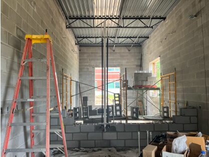
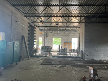
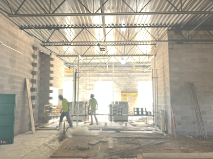
The Michigan Geological Repository for Research and Education (MGRRE) is moving from a leased facility to a new home on Western Michigan University’s (WMU) Parkview Campus, next to the College of Engineering and Applied Sciences, thanks in part to a $6 million state investment and support from WMU. This location strengthens an existing connection, as the Michigan Geological Survey works closely with the College of Engineering and Applied Sciences on shared research projects and looks forward to expanding opportunities for multidisciplinary collaboration.
We are posting new construction photos each week here on our MGS homepage so visitors can follow the progress as the new facility takes shape. Along with our project partners, Fishbeck, the architecture and engineering firm, and AVB, the construction management firm, we invite you to check back regularly for the latest updates.
Educational Opportunities
Explore educational opportunities with the MGS! Whether you’re a student, educator, or geoscience enthusiast, MGS has something for you.
- K-12 CoreKids Program: Access educational materials, classroom visits, and field trips tailored for K-12 students.
- Outreach Team: Partner with us to bring geoscience to your events. We offer exhibits and speakers to enhance your event experience.
- Career Development: Participate in career development activities, including large-scale exhibitions, local and regional events, and access digital resources available on our website.
Connect with the MGS Education and Outreach program to schedule your event.

What's New
The Great Lakes Geologic Mapping Coalition Fact Sheet 2026-3010
The Michigan Geological Survey is one of the state geological surveys that participates in the USGS Great Lakes Geologic Mapping Coalition (GLGMC), a federal-state partnership that funds and coordinates 3D geologic mapping across the Great Lakes region. In practice, Michigan’s work in the coalition helps produce better maps of near-surface geology and glacial sediments that support water, hazard, land-use, and resource decisions. Learn more about GLGMC activities by reading GLGMC Fact Sheet 2026-3010.
Limited MGRRE Services Until New Building Finished
Thank you for your patience as we prepare to move into our new facility. Beginning July 1st 2026, our archive of rock core will be unavailable to the public while construction of our new facility is completed and we transition into the new space. We appreciate your understanding during this period and look forward to serving you in our new location.
The Latest MGS Newsletter Is Here
To kick off winter 2025, we released our latest newsletter, highlighting key activities from the past year, including updates on the Core Kids program, the MGRRE core repository, the Triage project, and more. Read the full newsletter and explore our latest updates on the MGS Newsletter page.
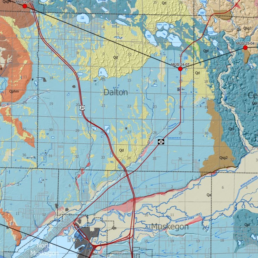
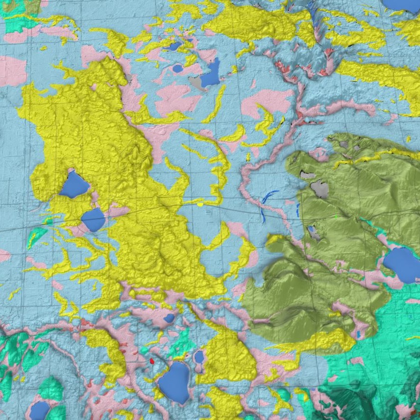
Surficial Geology Maps
In Fall 2025, we released a new surficial geology map for Muskegon County, an online web application for viewing the surficial geology of Allegan County in 2D and 3D, and the Michigan Borehole Inventory Dashboard. Links to the newly released maps and data are provided below.
Surficial Geology of Muskegon County
Recommended Citation:
Colgan, P.M., Erber, N.R., Ringle, G.B., Anderson, G.P., 2025, Surficial Geology of Muskegon County, Michigan, Michigan Geological Survey – Western Michigan University, Surficial Geologic Map Series SGM-25-01, Scale 1:62,500, September, 2025.
Allegan County Surficial Geology Web Application
Recommended Citation:
Colgan, P.M., Erber, N.R., Esch, J.M, Yellich, J.A., and Anderson, G.P., 2023, Surficial Geology of Allegan County, Michigan. Michigan Geological Survey – Western Michigan University, Surficial Geologic Map Series SGM-23-01, 1:62,500 Scale.
Michigan Borehole Inventory Dashboard Application
With this dashboard you can explore statistics about our cores and cuttings, information regarding other facilities that have Michigan specific cores, a calendar showing availability to visit our facilities, and other external resources by exploring our other pages.